Just over a year ago, Sheila Ruddick, who was the Museum’s Secretary and a Trustee for over twenty years, took a group of young people on a tour of Eastriggs. She showed them all the sites she had researched over the years for her own interest, for the Museum and for the map she produced ‘Eastriggs: Commonwealth Walk Guide’ (which is available from the Museum online shop – see below).
The young people (and Judith, the Museum Manager) enjoyed their afternoon exploring Eastriggs and listening to all the things that Sheila had to say. Sadly, it was not long after this that Sheila’s health declined and she passed away much to the sadness of all at the Museum.
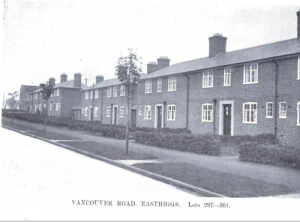
Vancouver Road as shown in an Auction Book from 1924 (when the Factory and townships were sold).
In case you aren’t aware, Eastriggs was built in World War One to house workers at HM Factory Gretna. It originally had a cinema, dance hall, fire station and other amenities such as hostels for the workers. The township was built along garden city principles and is named ‘The Commonwealth Village’ because its street names reflect the global nature of the workforce in the Factory (people came from India, Australia, South Africa etc. to contribute to the war effort here).
The young people involved have been working on and off on this map project for a year (there have been lots of interruptions due to study leave, people going to university etc.) but we have finally got an online version of the map in a condition to share with you.
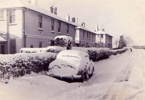
Snow on The Ridge. Date unknown.
You will find photographs and information online (155 posts in total) here:
https://www.historypin.org/en/eastriggs-the-town-that-world-war-one-built-2/geo/54.985551,-3.169917,11/bounds/54.828984,-3.34302,55.14151,-2.996814/paging/1/pin/1128318
On some photos, you can compare the historic images with the current google street view image. The photos date from different decades and there is information relating to who lived in some of the houses too.

The Green, Eastriggs, still recognisable today, it was originally built in World War One to include shops, a bank, cinema and dairy.